A cold winter’s day has left me daydreaming about summer, and one of those memories leads me to Uncompaghre Peak deep in the San Juan range. As one of Colorado’s most beautiful 14ers, the drive and hike to this summit is amazing and worth the time put in.
On a July morning, my best friend and I set out on a road trip, leaving our families and the Denver suburb of Littleton behind. A little ways down the road, we swung through Colorado Springs, loaded up on Rudy’s barbecue, then made our way to the quaint town of Lake City. Out of Lake City, we took a left on Henson Creek Road. Five miles later, the Nellie Creek trail pointed us in the right direction. Fortunately, I have 4WD, so we were able to continue up 4 more miles along the not-so-smooth Nellie Creek Road, crossing a stream two times and just hoping we wouldn’t get washed away.
At the end of the road near 11,400 feet, and after overcoming some crazy-big rocks in the road that at one point left my 4-Runner hanging over a boulder, we parked and made our camp for the evening. Please note the US Forest Service Restroom is closed. Don’t even thinking about opening the door! The stars were beautiful, but with a 4am start the next morning, we didn’t linger outside long.
Bright and early the next morning, we ate a few breakfast bars, packed the Gatorade, GPS, and cameras, as headed out on the trail.
The first portion of the trail ran along Nellie Creek near 11,800’ before reaching a junction and turning west into a large valley.

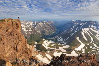
From here, the trail took us southwest and provided some great views along the way of our destination. The path was easy to follow and after making our way through a basin, up a few switchbacks still sprinkled with snow, and up the south ridge, we reached the 13,200’ mark. Near 13,800’ we reached the most difficult portion of the route – a long stretch of loose rocks partially covered in snow that lay beneath the upper slopes. Slowly, we picked our way through this area and up onto the ridge. Even the most difficult parts of this trail were only Class 2, but the snow and loose rock and sometimes muddy conditions helped us to focus a little more. We certainly didn’t want to turn an ankle at this altitude. After gaining the ridge, the trail was easy enough and led us to the summit at 14,309’ and provided views that linger in my mind as grand and spectacular.

We spent some time enjoying the Colorado Rockies and the Uncompaghre Wilderness that surrounded us. In the distance was Matterhorn Peak, another of Colorado’s 14ers and one that we hope to return and climb one of these summers. The views and summit we had all to ourselves.

After 30 minutes of rest, we returned the way we came, taking our time on some of the snow-covered loose rock. Our round trip was just under 8 miles and 3000 vertical feet. We were back at the trailhead in just a few hours, and not long after, as we followed Henson Creek Road back into Lake City, the bottom dropped out of the sky and afternoon monsoons blanketed everything with rounds and rounds of rain.
Our trip wasn’t complete, though. The next day we found ourselves hiking Maroon Pass between Crested Butte and Aspen. But that is another story for another cold, winter day.
Happy Travels, my friends.
~ Rob